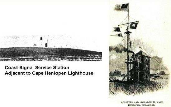
As the Navy prepared for the Spanish-American War, an Auxiliary Naval Force or "Mosquito Flotilla" was formed from the various state naval militias in order to defend the nation's ports and harbors from enemy attack. To support that force by alerting it to the approach and location of the enemy, a Coast Signal Service, also manned by state naval militia personnel, was formed. One of the 29 primary stations of that service was at Cape Henlopen. The station occupied the former Philadelphia Maritime Exchange building adjacent to the Cape Henlopen lighthouse.
|
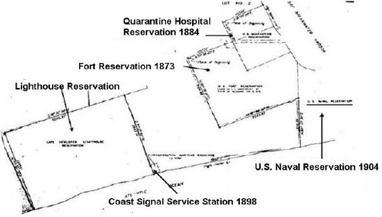
By 1899, however, the Navy had begun evaluating and testing Guglielmo Marconi's new system of wireless telegraphy. By Spring 1903, five shore stations and eight ships were equipped with a variety of wireless systems and additional shipboard installations and shore stations had been proposed. By 1904, some thirty coastal stations had been approved, extending along the Gulf and East Coasts and including one on Cape Henlopen. A naval reservation was acquired on the tip of the Cape for the establishment of a naval wireless station.
|
By October 1905, twenty three shore stations already had been equipped and thirteen more were building, including the station at Cape Henlopen which was completed in 1906.
|
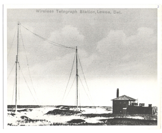
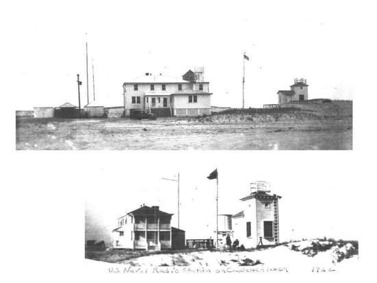
Naval Wireless Telegraph Station, Cape Henlopen in 1906.
The station covered about 3 acres and consisted of a main building for quarters and operations spaces, a power building and storage building. There was a transmitting antenna (in the foreground) and a receiving antenna ( in the background.
|
The vertical transmission antenna (above) was built like a mast of a sailing ship, constructed of several long wooden poles lashed together by steel wire ropes and held upright by a number of guy wires. It was 150 feet in height.
The horizontal receiving antenna consisted of two poles about 150 feet apart with multiple wires strung between them.
|
Upon establishment, the station was equipped with a spark gap transmitter from the Massie Telephone and Telegraph company.
During the early period of its operations, Cape Henlopen operated at 3 kilowatts in the medium frequency range. The callsign was PX. In 1910 the call sign was NAJ.
|
Portion of USCGS map 379 dated 1910, showing location of the Naval Wireless Station on the Cape with respect to the Cape Henlopen Lighthouse (lower right) and the Breakwater Quarantine Hospital (left).
|
Advances in technology soon permitted powerful radio
transmitters and sensitive receivers. The Naval Radio Service was established and existing wireless stations were converted to radio stations. To convert the wireless station at Cape Henlopen to a radio station, a set of radio equipment originally designated for a district vessel was temporarily placed at the station until it could be replaced by standard navy shore station radio equipment.
|
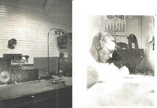
Radio equipment at Naval Radio Station, Lewes in 1916.
|
In preparation for WW I, the Navy was directed to take responsibility for all U.S. government radio communications and take over all government and commercial radio stations required. All others were to be closed. Amateurs were directed to cease operations and dismantle their equipment.
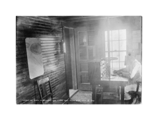
Accordingly the Fourth Naval District took over a commercial transmission station atop the Wanamaker Building in Philadelphia and a Marconi-owned transmit and receive station at Cape May (shown) for command and control of Fourth Naval District forces.
|
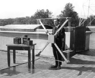
To enforce the restrictions on amateur radio transmissions and to detect possible transmissions from enemy agents, special listening stations were established and provided with newly-developed direction- finding (DF) antennae (shown). Two stations were established in Philadelphia for the purpose.
.
|
During the war, Naval Radio Station, Lewes was used to communicate with district patrol vessels and ships in the immediate Cape area and for controlling the movement and anchorage of all ships in the approaches to Delaware Bay and in the Breakwater Harbor.
In addition, the station was responsible for maintaining continuous watches on the international calling frequencies of 500 and 1,000 kilocycles at fifteen to eighteen and forty-five to forty-eight minutes after the hour for the purpose of guarding for distress signal transmissions. This was especially important as the German submarine campaign reached the coast of the U.S., sinking numerous ships approaching the Cape.
|
Naval Radio Station, Lewes Radioman First Class
radio room. Charles S. Horn, Jr. on watch.
|
During the war, the German submarine operations against shipping off the Cape had shown that every hour a ship lost by slowing due to poor visibility and every day ships were kept at sea because of their inability to enter fogbound harbors they were increasingly vulnerable to attack.
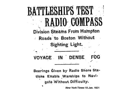
Thus, in mid-1918, anticipating an increased flow of convoys returning from Europe, the Navy began the establishment of "Radio Compass Stations" equipped with DF antennas in groups of three around the approaches to the major east coast ports and the entrances to the Delaware and Chesapeake Bays. One station of each group would operate as the master or controlling station with two “slave” stations. By coordinating simultaneous bearings taken by all three, the master station could provide a ship with its location, improving its navigation and expediting its approach and entry into harbor.
The process of converting Naval Radio Station, Lewes into a Compass Station begun in December 1918. A new building and antenna were built just north of the former radio station building. The “slave” stations were established at the Cape May radio station and in a new building just south of the lifesaving station in Bethany Beach.
|
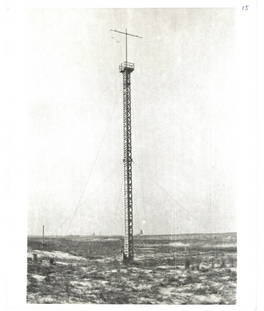
The radio direction-finding station or "Naval Radio Compass Station" in 1919.
|
The direction-finding antenna at the Naval Compass Station in 1919.
|
While these stations were not completed by the end of the war, they proved useful in following years.
|
To obtain its position, a ship called Radio Compass Station, Lewes on the radio using the call sign NSD. Lewes alerted the Cape May and Bethany stations by telephone or radio and acknowledged reception to the ship. Upon being acknowledged, the ship sent a series of three long dashes and operators at the three stations obtained bearings on that signal.
The DF antenna at Cape Henlopen did not rotate as it was positioned to look directly at the approaches to the Cape and could develop a more exact bearing by the strength of the signal across the antenna. The DF operators at the Cape May and Bethany stations rotated their antennas by a wheel that controlled the antenna. (See picture.) When they received the strongest signal, the face of the antenna would be pointing at the ship and a compass ring at the base of the pole on which the wheel was mounted would indicate the true direction the antenna was pointing, thus giving the bearing of the ship from the station. Cape May and Bethany forwarded their cross bearings to Lewes for plotting.
|
These bearings were plotted on a large chart of Delaware Bay mounted on a board which was hinged to the wall near the operator's desk. (See picture) The board could be pulled down to form a plotting table. It had a hole in it at the location of each station and a string was threaded through that hole. On one end of the string on the chart side was a pin and on the underside was a weight. A compass rose was printed on the chart around the hole for the location of each station. The string was pulled through the hole until the weight stopped it and it was aligned on the board with the bearing of the ship reported from that station and the pin was stuck in the board. The bearing from Cape Henlopen and the cross-bearings from Cape May and Bethany provided a triangulated fix on the position of the ship.
Given the sensitivity of the equipment to get a precise line of bearing and the crudeness of the plotting system, the strings would not usually cross at a point. Rather, they would indicate a triangular area within which the ship would be located.
|
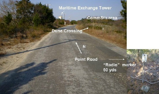
In 1932, the U.S. Coast and Geodetic Survey placed a marker "RADIO" some yards to the south of the station, fixing its location accurately.
Then, on 11 May 1933, the Navy ordered a number of installations closed on 1 July 1934. Among the announced closings were the Navy Radio Compass Stations at Lewes, Bethany Beach and Cape May. Nevertheless, the station continued to be manned at some level until, in WW II, it was taken over and used by the Harbor Entrance Control Post (HECP). (For HECP, go here____.)
|
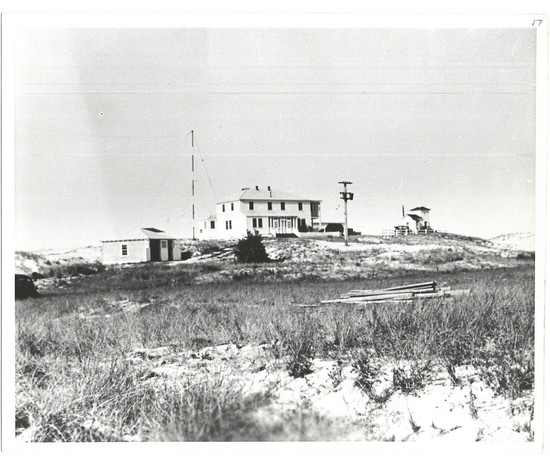
Two views of Naval Compass Station, Lewes in 1922.
|
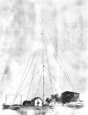
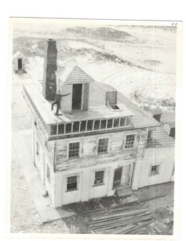
Meanwhile, the building of the former Wireless Telegraphy Station continued to deteriorate until it was torn down with the establishment of Fort Miles.
|
No evidence of these facilities remain in Cape Henlopen State Park today.
|
Area of the former naval communications today.
|
Photo Credits
-Coast Signal Service station adjacent to Cape Henlopen Lighthouse. Coast Guard photo from 1891 with permission from Jack Beach, Cape Henlopen Lighthouse and Delaware Breakwater.
-1898 Coast Signal Station: From Century Magazine 1901.
-Naval Reservation on Cape Henlopen. Portion of map titled "Harbor Defense of the Delaware" "Property to be acquired from the state of Delaware" included in the Fort Miles Record Book courtesy of the Fort Miles Historical Association. Cropped and annotated by author.
-Naval Wireless Station in 1906: From: Franklin Brittingham Collection 205-12-1257. Courtesy of the Lewes Historical Society and Hazel Brittingham.
-Naval Wireless Station Transmitter: From a brochure published by the Continental Wireless Telephone and Telegraph Company dated April 1908. Accessed via www.ieeeghn.org.
-Radio equipment at Cape Henlopen in 1916: From the Horn Collection. Courtesy of James G. Horn.
-Naval Radio Station Cape May: From Wireless Age, June 1917.
-Direction-finding antenna: From National Institute of Science and Technology Photo Gallery. Accessed via www.nist.gov..
-Naval Section Base radio room and Radioman First Class: From Horn Collection. Courtesy of James G. Horn.
-Naval Compass Station in 1919: From Horn Collection. Courtesy of James G. Horn.
-Naval Compass Station antenna: From Horn Collection. Courtesy of James G. Horn.
-Naval Compass Station 1922: From Franklin Brittingham Collection Courtesy of Lewes Historical Society and Hazel Brittingham.
-Old Naval Wireless Station: From Horn Collection. Courtesy of James G. Horn.
-Current view of Naval Communications Station area on Cape Henlopen: Author’s photo and annotation.
|
|
|